Columbia Gorge
-
 An Elaborate Fishing Platform at Celilo Falls - circa 1942As low as $5.00This World War II era photo shows that while fishing platform footings and men's clothing had changed, the basic technology and fishing techniques at Celilo had stayed pretty much the same. Learn More
 -
 Approaching Mitchell's Point, Columbia River Highway - c. 1923As low as $5.00Most people know Mitchell's Point as the location for the tunnel with windows, built for the historic Columbia Gorge Highway in 1915. Learn More
 -
 Beacon Rock from Columbia River Highway - 1936As low as $5.00Spokane photographer Leo Oestreicher captured some wonderful scenic views during his varied career. Most were taken to be used as postcards, ours are recreated from his original negatives. Learn More
 -
 Beacon Rock, on the Columbia River - 1936As low as $5.00This highly detailed portrait of Beacon Rock was created by Spokane photographer Leo Oestreicher on March 31, 1936. Learn More
 -
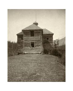
 Blockhouse at Upper Cascades, Columbia River - c. 1885As low as $5.00Built in 1856, this blockhouse was only used for a few years but lasted for decades afterwards. The Cascades were a strategic military site during unrest between early settlers and the Native American inhabitants. Learn More
 -
 Blockhouse, Upper Cascades, Columbia River - 1860As low as $5.00Fort Lugenbeel, also known as the Upper Blockhouse, was built in 1856 after the "Cascades Massacre" of the Yakima Indian Wars occurred just downstream. Learn More
 -
 Boating at Castle Rock - c. 1901As low as $5.00Two properly attired women manage their rowboats in the foreground of this idyllic scene at Castle Rock, now known as Beacon Rock, on the Columbia River. Learn More
 -
 Bonneville Dam, Columbia River - 1939As low as $5.00Ralph Eddy was fascinated with the interplay between built structures like bridges and dams, and the natural environment where they were placed. This view shows the Bonneville Dam shortly after it was completed in 1937. Learn More
 -
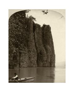
 Bridal Veil Bluffs, Columbia Gorge - 1880sAs low as $5.00The Bridal Veil Bluffs and the Pillars of Hercules are adjoining basalt formations in the Columbia Gorge. Learn More
 -
 Bridal Veil Falls - 1880sAs low as $5.00Bridal Veil Falls, the only falls below the historic Columbia Gorge Scenic Highway. Learn More
 -
 Bridal Veil, Snow Bound - c. 1885As low as $5.00The photographer's title apparently refers to the person in the cabin, rather than the train, which seems to be getting through heading up-river. Learn More
 -
 Building the Dalles - Celilo Canal - 1910As low as $5.00The Dalles-Celilo canal, over eight miles long, begins about three miles upriver from The Dalles. Its construction lasted from 1905 through 1915. Learn More
 -
 Cape Horn - 1880sAs low as $5.00A rowboat makes its way along the edge of Cape Horn, on the Washington side of the Columbia River. Learn More
 -
 Cape Horn on the Columbia River - c. 1900As low as $5.00This very detailed view of Cape Horn is reproduced from an original glass negative created by Oregon photographer Jesse A. Meiser in about 1900. Learn More
 -
 Cape Horn, Columbia River - Near View - 1870sAs low as $5.00This near view of Cape Horn shows several small waterfalls amid the pinnacles. Learn More
 -
 Cars and Motorcycles at Shepperd's Dell Bridge - c. 1916As low as $5.00An unknown photographer captured this scene of cars and motorcycles at Shepperd's Dell Bridge on the Columbia River Highway, shortly after the highway was opened in 1916. Learn More
 -
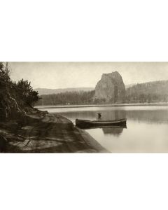
 Castle Rock - c. 1900As low as $5.00This highly detailed view of Castle Rock (now called Beacon Rock) was taken looking upstream from the north bank of the Columbia River by Vancouver photographer Jesse Meiser. Learn More
 -
 Castle Rock from the Oregon Side - 1880sAs low as $5.00An unusual view of Castle Rock (now Beacon Rock) from across the Columbia River. Learn More
 -
 Castle Rock, Columbia River, Near View - c. 1878As low as $5.00Now known as Beacon Rock, this striking feature is located near Skamamia on the northern side of the Columbia. Learn More
 -
 Celilo Falls on the Columbia - 1900As low as $5.00This view of three men looking over Celilo Falls is one of Benjamin Gifford's better-known photos, and rightly so. Learn More
 -
 Celilo Falls, Circa 1915As low as $5.00This image, recreated from a detailed larger print, shows another edition of the evolving fishing structures at Celilo Falls. Learn More
 -
 Celilo Falls, Washington Side - 1890sAs low as $5.00This view of Celilo Falls from the Washington side was captured by D. C. Herrin of the Dalles in the 1890s. Learn More
 -
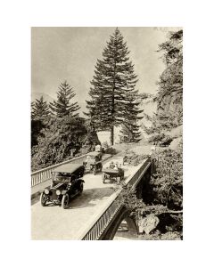
 Chanticleer Inn, Columbia River Highway - c. 1916As low as $5.00The Chanticleer Inn, at the west end of the Columbia River Highway, was built in 1912 and predated the highway. Like many early wooden inns, it burned down, in 1930. Learn More
 -
 Closeup of Old Blockhouse at the Cascades - 1880sAs low as $5.00This closeup view shows how the solidly built blockhouse still persisted thirty years after it was abandoned. Learn More
 -
 Columbia Gorge from Crown Point - 1932As low as $5.00Looking upstream in the Columbia Gorge, with the photographer standing near Vista House at Crown Point. The decorative wall and lamps are still there today. Learn More
 -
 Columbia River Highway at Multnomah Falls - 1923As low as $5.00This is one of Ralph Eddy's earliest photos of the Columbia Gorge - a location where he would soon establish his postcard stand and build a career. Learn More
 -
 Columbia River Highway Under Tooth Rock - 1927As low as $5.00We're looking upstream at Tooth Rock Viaduct, devised as a way to allow the new scenic highway to pass around the rock without destroying it by blasting. Learn More
 -
 Columbia River Railroad Bridge at Celilo - c. 1912As low as $5.00Looking across the Celilo railroad bridge shortly after its completion in 1912. Learn More
 -
 Construction of Columbia River Highway, with Temporary Railroad - 1915As low as $5.00Many historic photos exist of the Columbia River Highway. This one is unusual, showing the temporary railroad used to move heavy materials along the highway grade during construction. Learn More
 -
 Crown Point and Vista House - c. 1921As low as $5.00Cross and Dimmitt made several hand-tinted versions of this photo. This is the water color version. Learn More
 -
 Crown Point Before Vista House - c. 1916As low as $5.00This unusual view shows Crown Point before Vista House was built, but apparently after the Columbia River Highway was completed. That would date it to a short span of time in 1916. Learn More
 -
 Crown Point from Rooster Rock - circa 1920As low as $5.00This photo of Crown Point and Vista House is unusual as it was taken from across the river, and it also shows an excursion train passing below Crown Point at water level. Learn More
 -
 Crown Point, Columbia River Highway - c. 1920As low as $5.00Photographer Clark Kinsey is best know for his logging photos, but he also had a great touch for scenic views of the Pacific Northwest. Learn More
 -
 Eagle's Nest Closeup, Columbia River Highway - c. 1916As low as $5.00This image is recreated from a hand-colored print made by the Fred Kiser Company, as part of a series publicizing the new scenic highway. Learn More
 -
 Eagle's Nest, Columbia River Highway - c. 1916As low as $5.00"Eagle's Nest" is the name given by Samuel Lancaster to this small viewing area when he designed it as part of the Columbia River Highway. Learn More
 -
 East of Multnomah Falls, Columbia River Highway - c. 1916As low as $5.00Many of Kiser's Columbia River Highway photos contrast the geometric lines of bridges and railings with the organic forms of the Columbia River Valley. Learn More
 -
 Elowah Falls in Autumn, Columbia River Highway - c. 1916As low as $5.00Elowah Falls are on McCord Creek, and were originally called McCord Falls, which is the name given on our hand-tinted original print. Learn More
 -
 Elowah Falls Through the Trees - Circa 1915As low as $5.00Elowah Falls are located on McCord Creek, about five miles east of Multnmomah Falls in the Columbia Gorge. Learn More
 -
 Elowah Falls, Columbia River Gorge - c. 1915As low as $5.00One of the "hidden gems" of the Columbia Gorge, Elowah Falls can be reached by an easy 3/4 mile hike. Learn More
 -
 Engine 132 Passing Through The Needles - c. 1900As low as $5.00A steam engine on the line of the Oregon Railway & Navigation Company (O R & N) passes between the two spires of The Needles on its way up the Columbia River. Learn More
 -
 Evergreen Highway, Looking West at Rock Shed Around Cape Horn - c. 1930As low as $5.00In 1927, thirty-seven tons of dynamite were used to clear the way for the Evergreen Highway to extend around the river side of Cape Horn in Washington. Unfortunately, the blast loosened much more rock than anticipated, and hundreds of feet of railroad as well as buildings and a farm were covered in the ensuing landslide. Learn More
 -
 Fairy Falls, Columbia Gorge - 1890sAs low as $5.00This photo comes from an unlabeled D. C. Herrin boudoir card; thus we're guessing a bit when we identify them as Fairy Falls. We're confident they're in the Columbia Gorge. Learn More
 -
 Fish Wheel at Upper Cascades, Columbia River - c. 1885As low as $5.00Fish wheels, water-powered mechanisms that "mined" salmon, were active on the Columbia River from 1879 through 1934. Learn More
 -
 Fish Wheel near the Lower Cascades - 1900sAs low as $5.00A detailed view of an elaborate fixed fish wheel on the bank of the Columbia River. Learn More
 -
 Fish Wheel on Columbia River - 1905As low as $5.00According to the original caption, this fish wheel near The Dalles would "take out half a ton of salmon daily". Learn More
 -
 Fish Wheel, Near Bradford's Island, Columbia River - c. 1880As low as $5.00This photo shows an early fish wheel on the Columbia River, near Bradford's Island, which is now submerged behind Bonneville Dam. Learn More
 -
 Fishing with a Dip-net at Celilo Falls - 1942As low as $5.00This dramatic photo shows the size of some of the dip-nets used to catch salmon at Celilo Falls on the Columbia River. Learn More
 -
 Fishing, Old and New, at Celilo Falls - 1910sAs low as $5.00This fishing photo shows two methods of taking salmon at the falls. Learn More
 -
 Government Locks at the Cascades, Columbia River - c. 1890As low as $5.00It took 18 years to build these locks, which were completed in 1896. They operated for forty years, until being submerged by Bonneville Dam in 1938. Learn More
 -
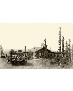
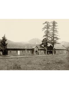 Grandpa & Grandma Munra at Bonneville Eating House - 1888As low as $5.00Katherine and Selkirk Munra were known as Grandma and Grandpa Munra when they ran the Bonneville Eating House, along the tracks of the O R & N near the current site of the Bonneville Dam. Learn More