Rivers and Streams
-
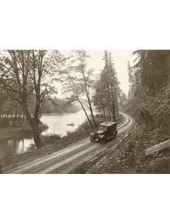 Along the McKenzie River - 1921As low as $5.00Good photos bring you into the scene. This view of the McKenzie River by Eugene photographer Edmund Martin definitely qualifies by that criteria. Learn More
 -
 Along the Willamette River, Oregon City - 1940As low as $5.00This well-composed view shows the concrete Pacific Highway entering Oregon City. Then a national highway, 99E was removed from the federal system in 1972. Learn More
 -
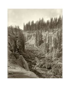 Annie Creek Canyon, Near Crater Lake - c. 1908As low as $5.00This view of Annie Creek Canyon is reproduced from an original glass negative by Howard Tibbitts, who was based in San Francisco where he worked for Sunset Magazine. Learn More
 -
 Arch Bridge Vista, Oregon City - c. 1950As low as $5.00A striking view that contrasts the natural landscape with the built structure of the bridge, taken by photographer Ralph Eddy near the end of his professional career. Learn More
 -
 Arlington, Oregon, on the Columbia River - 1939As low as $5.00Arlington is an early Oregon town located on the Columbia River at the mouth of Alkali Canyon, about fifty miles east of The Dalles. In the early 1870s, settlers built corrals here to hold sheep and cattle waiting to be transported downriver. Learn More
 -
 Ashland Creek in Lithia Park, Ashland - 1932As low as $5.00This view of Ashland Creek received more positive comments than any other photo in our 2012 Ralph Eddy Exhibit at the Clackamas County Historical Society. Learn More
 -
 At the Mouth of the Tualatin - c. 1930As low as $5.00In a location that looks much the same today, a young woman poses on a rock where the Tualatin flows into the Willamette. The original for this view is a hand-colored print from a black and white photograph. Learn More
 -
 Baker's Bridge, Across the Clackamas River - c. 1900As low as $5.00This rare early view shows the original wooden covered bridge that crossed the Clackamas River at Carver, reported to have been the longest covered bridge in Oregon at the time of its completion. Learn More
 -
 Boating at Castle Rock - c. 1901As low as $5.00Two properly attired women manage their rowboats in the foreground of this idyllic scene at Castle Rock, now known as Beacon Rock, on the Columbia River. Learn More
 -
 Bonneville Dam, Columbia River - 1939As low as $5.00Ralph Eddy was fascinated with the interplay between built structures like bridges and dams, and the natural environment where they were placed. This view shows the Bonneville Dam shortly after it was completed in 1937. Learn More
 -
 Boones Ferry, near Wilsonville - c. 1908As low as $5.00A tranquil view of the old Boones Ferry, near Wilsonville. Learn More
 -
 Bridal Veil Bluffs, Columbia Gorge - 1880sAs low as $5.00The Bridal Veil Bluffs and the Pillars of Hercules are adjoining basalt formations in the Columbia Gorge. Learn More
 -
 Building on the Edge - 1890sAs low as $5.00A rather surreal photograph of a building overhanging the edge of a channel at the Dalles. Learn More
 -
 C & E Railway Trestle and Baker's Covered Bridge at Carver - c. 1930As low as $5.00This photo was taken at the time the old covered bridge was being replaced by a new steel bridge, and the railroad trestle to the left was under construction. Learn More
 -
 Cape Horn - 1880sAs low as $5.00A rowboat makes its way along the edge of Cape Horn, on the Washington side of the Columbia River. Learn More
 -
 Cape Horn on the Columbia River - c. 1900As low as $5.00This very detailed view of Cape Horn is reproduced from an original glass negative created by Oregon photographer Jesse A. Meiser in about 1900. Learn More
 -
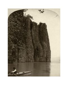
 Cape Horn, Columbia River - Near View - 1870sAs low as $5.00This near view of Cape Horn shows several small waterfalls amid the pinnacles. Learn More
 -
 Cascades of the Columbia - c. 1890As low as $5.00The Cascade Rapids on the Columbia River were one of two sections of the river that blocked passage for steamboats, the other being The Dalles. Learn More
 -
 Cascades of the Columbia and Cascade Locks - c 1885As low as $5.00We're looking over a movable fishwheel, sometimes called a fish scow, towards the Cascade Locks under construction and the town of Cascade Locks behind them. Learn More
 -
 Cascades of the Columbia and Cascade Locks - c. 1921As low as $5.00Completed in 1896, Cascade Locks allowed river traffic to bypass the Columbia River Cascades until they were submerged in 1938, replaced by Bonneville Lock and Dam. Learn More
 -
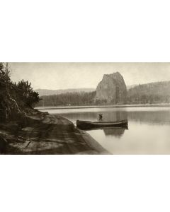
 Castle Rock - c. 1900As low as $5.00This highly detailed view of Castle Rock (now called Beacon Rock) was taken looking upstream from the north bank of the Columbia River by Vancouver photographer Jesse Meiser. Learn More
 -
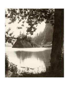
 Castle Rock from the Oregon Side - 1880sAs low as $5.00An unusual view of Castle Rock (now Beacon Rock) from across the Columbia River. Learn More
 -
 Cedar Island and Beavertail Ridge, Deschutes River - c. 1909As low as $5.00This overview of Beavertail Ridge is recreated from a glass negative made by George Weister during the Deschutes River Railroad War. You can see tracks being constructed on both sides of the river. Learn More
 -
 Clackamas River Near Estacada - 1922As low as $5.00One of Ralph Eddy's earliest landscape photos, this view looks up the Clackamas River at an unknown location - probably not too far from Eddy's home in Oregon City. Learn More
 -
 Columbia Gorge from Crown Point - 1932As low as $5.00Looking upstream in the Columbia Gorge, with the photographer standing near Vista House at Crown Point. The decorative wall and lamps are still there today. Learn More
 -
 Columbia River Highway at Multnomah Falls - 1923As low as $5.00This is one of Ralph Eddy's earliest photos of the Columbia Gorge - a location where he would soon establish his postcard stand and build a career. Learn More
 -
 Columbia River Highway, Ten Miles West of The Dalles - 1925As low as $5.00Photographer Darius Kinsey is best known for his logging photos in Washington state, but he also visited Oregon and created a series of scenic views along the Columbia River. Learn More
 -
 Columbia River near White Salmon c. 1916As low as $5.00Pine trees dominate the foreground in this scenic photo by Fred Kiser. His ability to quickly create artistic compositions is demonstrated by the thousands of scenic views he captured during his career. Learn More
 -
 Columbia River Valley and Highway from Rowena Heights - 1927As low as $5.00At first glance, this looks like Crown Point on the left, but it's actually Rowena Heights - about halfway between Hood River and The Dalles on the Columbia River Highway. Learn More
 -
 Crown Point Before Vista House - c. 1916As low as $5.00This unusual view shows Crown Point before Vista House was built, but apparently after the Columbia River Highway was completed. That would date it to a short span of time in 1916. Learn More
 -
 Crown Point, Columbia River Highway - c. 1920As low as $5.00Photographer Clark Kinsey is best know for his logging photos, but he also had a great touch for scenic views of the Pacific Northwest. Learn More
 -
 Deschutes River at Twin Crossings - circa 1910As low as $5.00Construction has just begun for the south railroad trestle across the Deschutes at Milepost 44, north of Sherars Falls. Learn More
 -
 East of Multnomah Falls, Columbia River Highway - c. 1916As low as $5.00Many of Kiser's Columbia River Highway photos contrast the geometric lines of bridges and railings with the organic forms of the Columbia River Valley. Learn More
 -
 Echo Bay and Falls, Columbia River - 1880sAs low as $5.00This nicely-composed photo was created by Frank J. Haynes, who though based in Dakota Territory, traveled several times to Oregon to create a series of stereoviews. Learn More
 -
 Evergreen Highway, Looking West at Rock Shed Around Cape Horn - c. 1930As low as $5.00In 1927, thirty-seven tons of dynamite were used to clear the way for the Evergreen Highway to extend around the river side of Cape Horn in Washington. Unfortunately, the blast loosened much more rock than anticipated, and hundreds of feet of railroad as well as buildings and a farm were covered in the ensuing landslide. Learn More
 -
 Father and Son at the Deschutes River - 1904As low as $5.00A Ponderosa Pine provides a backdrop for this portrait of a father and son admiring the Deschutes River on a beautiful sunny day, over 100 years ago. Learn More
 -
 Fields Covered Bridge, on the Tualatin River - c. 1935As low as $5.00The last of four Fields Covered Bridges over the Tualatin River, west of Willamette. Learn More
 -
 Fish Wheel at Bradford's Island - c. 1890As low as $5.00The original title of this photo didn't even mention the fish wheel; it was just called "Bradford's Island, Columbia River". Learn More
 -
 Fish Wheel at Upper Cascades, Columbia River - c. 1885As low as $5.00Fish wheels, water-powered mechanisms that "mined" salmon, were active on the Columbia River from 1879 through 1934. Learn More
 -
 Fish Wheel on Columbia River - 1905As low as $5.00According to the original caption, this fish wheel near The Dalles would "take out half a ton of salmon daily". Learn More
 -
 Fish Wheel, Near Bradford's Island, Columbia River - c. 1880As low as $5.00This photo shows an early fish wheel on the Columbia River, near Bradford's Island, which is now submerged behind Bonneville Dam. Learn More
 -
 Fishing in Eden - circa 1915As low as $5.00Recreated from the original glass negative, this view shows one of many beautiful fishing holes in the state of Oregon. Learn More
 -
 Flume for Cazadero Powerhouse - 1910As low as $5.00The Cazadero flume was completed in 1907, built from wood to bring water from the Cazadero Dam on the Clackamas river to Faraday Lake, which then powered the Cazadero powerhouse. Learn More
 -
 Fort Canby & "Big Betsy" Cannon - c. 1900As low as $5.00"Big Betsy" was the nickname given to Fort Canby's 15-inch Rodman cannon, the largest of the fort's muzzle loading cannons. Learn More
 -
 Gold Ray Dam, Rogue River - circa 1912As low as $5.00The original for this view is a larger print made by Kunselman and Gerking of Klamath Falls, looking across the Gold Ray Dam, which had been built in 1904. Learn More
 -
 Gold Ray Dam, Rogue River, Looking Downstream circa 1912As low as $5.00Completed in 1904, the Gold Ray Dam was built for brothers Colonel Frank H. Ray and Dr. C. R. Ray to provide power for their gold mine in Gold Hill. It was located about four miles upstream from Gold Hill on the Rogue River. Learn More
 -
 Harvest Queen Working as a Tug on the Columbia - c. 1903As low as $5.00Larger sternwheelers were occasionally pressed into service as tugboats to help guide tall masted ships through the narrow passages of the Columbia River. Learn More
 -
 Hercules Pillars, on the Columbia River - 1907As low as $5.00This detailed photo of Hercules Pillars, also called The Needles, was created as a glass negative by Howard C. Tibbitts, photographer for Union Pacific and their Sunset magazine. Learn More
 -
 Hood River Bridge - 1926As low as $20.00The Hood River Bridge is the second oldest bridge built across the Columbia between Oregon and Washington, having been completed in 1924, shortly before this photo was created. Learn More
 -
 Hood River from the Eastside Grade - c. 1910As low as $5.00Looking north down Hood River from the east bank, we see the town named after the river to the left. In the distance is the Columbia River, and the hills of Washington State on the other side. Learn More